Ford put one camera where no tech company had the guts to go
Americans love the open road.
But there's one legendary route most people will never experience in person.
And Ford just brought 5,900 miles of America's toughest terrain to everyone's computer screen in one surprising way.
Google Street View goes where cameras feared to tread
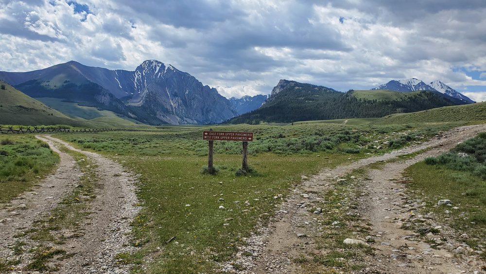
The TransAmerica Trail spans more than 5,900 miles from the Oregon coast to North Carolina's beaches.¹
This isn't some paved highway tourists snap photos on from their minivans.
The TAT snakes through 13 states on dirt roads, gravel tracks, and mountain passes that most vehicles would never survive.
Sam Correro spent 12 years charting this beast of a route back in 1984, using only publicly accessible roads and trails that could handle motorcycles and serious off-road vehicles.²
For decades, the trail has been reserved for hardcore overlanders and adventure seekers willing to risk breakdowns miles from civilization.
Until now.
Ford teamed up with Google to do something no automaker has ever attempted with Street View — mapping America's longest off-road trail in its entirety.³
A Ford Bronco Badlands with the Sasquatch Package carried Google's 360-degree camera rig on its roof for 32 days straight.
Over 32 days, the team battled through Utah's Great Salt Lake Desert and climbed Colorado's San Juan Mountains above 11,789 feet before reaching the Atlantic in North Carolina.⁴
The Bronco handled terrain that destroys ordinary vehicles
Ford didn't send the Bronco out alone to tackle this challenge.
A Ranger Lariat pickup with the FX4 Off-Road Package and an Expedition Tremor SUV followed as support vehicles, hauling gear and crew across month-long trek that covered some of America's most punishing landscapes.⁵
The route has no official signs or single established path, forcing the team to improvise when they hit roadblocks.
Ford's directive was simple — stay off pavement as much as humanly possible.
The Bronco Sasquatch came equipped with 35-inch tires, Bilstein shocks with position-sensitive damping, and a twin-clutch rear-drive unit with locking differentials designed specifically to conquer extreme off-road conditions.⁶
That hardware got put to the test crossing sandy deserts, rocky mountain passes, and forest tracks that would leave most crossovers stranded.
The expedition took place in August 2025, resulting in hundreds of thousands of panoramic images now uploaded to Google's servers.⁷
Anyone with an internet connection can now virtually scout terrain, check seasonal conditions, and visualize routes before committing to the real thing.
This opens doors most Americans didn't know existed
This marks the first time Google has partnered directly with an automaker to chart a route for Street View.⁸
The camera system Ford used weighs less than 15 pounds — a far cry from the massive rigs Google used to deploy on city streets.
That portability meant the team could quickly mount and dismount equipment as terrain changed, keeping the expedition moving without heavy hardware slowing them down.
Google's Street View launched in 2007 and has since captured more than 220 billion images across over 100 countries.⁹
But the service has largely stuck to paved roads and tourist destinations that generate clicks.
The TransAmerica Trail represents something different entirely — a visual record of America's hidden landscapes that rarely appear on tourist maps.
Ford insists this wasn't just a marketing stunt to show off the Bronco's capabilities.
The Street View imagery gives overlanders a genuine tool for planning expeditions, identifying potential hazards, and understanding what equipment they'll need before leaving pavement behind.
Sam Correro's original route was designed for dual-sport motorcycles that could cover around 200 miles per day.¹⁰
The trail became a bucket-list journey for riders and 4×4 enthusiasts willing to dedicate over a month to crossing the country without touching tarmac.
Now suburban families can experience what Correro spent over a decade mapping — without risking breakdowns in the middle of nowhere.
Google and Ford just changed how Americans explore their own backyard
This project reveals how much of America remains unexplored by everyday citizens.
The TAT crosses federal forests, mountain ranges, and desert landscapes that most people only see in photos.
Making it accessible through Street View democratizes adventure in a way that didn't exist before.
Ford gets to showcase the Bronco doing what it was built for — handling terrain that would destroy competitors.
Google expands its Street View empire beyond city streets into territory that required serious off-road hardware to capture.
And Americans who'll never own a Bronco or attempt the TAT get to see parts of their country that remained hidden from view.
The implications go beyond virtual tourism.
Emergency services can scout remote areas for rescue planning, environmental researchers can document changing landscapes over time, and future overlanders can prepare for expeditions with unprecedented detail about what lies ahead.
This won't replace the real experience of tackling the TransAmerica Trail with mud on your tires and dust in your face.
But it might inspire more Americans to discover what lies beyond the pavement — and that's something this country desperately needs.
¹ Thanos Pappas, "A Ford Bronco Just Took Google Street View Where No Camera Had Gone Before," AutoEvolution, October 28, 2025.
² "Trans America Trail – Wikipedia," Wikipedia, June 17, 2025.
³ "Ford Bronco Helps Bring TransAmerica Trail to Google Maps," Motor1, October 27, 2025.
⁴ Thanos Pappas, "A Ford Bronco Just Took Google Street View Where No Camera Had Gone Before," AutoEvolution, October 28, 2025.
⁵ Ibid.
⁶ "The 2025 Ford Bronco Sport Sasquatch Is More Off-Roader Than Most People Will Ever Need," The Autopian, April 11, 2025.
⁷ Thanos Pappas, "A Ford Bronco Just Took Google Street View Where No Camera Had Gone Before," AutoEvolution, October 28, 2025.
⁸ "Ford Bronco Helps Bring TransAmerica Trail to Google Maps," Motor1, October 27, 2025.
⁹ "Google Street View – Wikipedia," Wikipedia, September 14, 2025.
¹⁰ "The Trans-America Trail: Your Guide to The Greatest Off-Roadtrip," The Dyrt, February 5, 2024.


